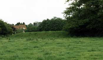
Site 8 - Medieval Watermill
The large earthwork at this point forms the impressive remains of a medieval dam, which would have created a lake as far back as the bridge on Cryfield Grange Lane (see Medieval Crossing). This lake stood at the head of a series of such water features stretching southwards down the Canley Brook valley as far as Crackley at the northern edge of Kenilworth. These dams and lakes are a significant aspect of the monastic development of the area.
A royal grant in the 12th century allowed the construction of a monastery at Cryfield on land that had formed part of the royal hunting estate at Stoneleigh (dating back to Saxon and Norman times). Shortly after its foundation the monks moved their monastic buildings to Stoneleigh, claiming that the site at Cryfield was too disturbed - perhaps by the industrial activities associated with the potteries in Tocil Wood (see Medieval Pottery). Traces of the central monastic buildings, including its church and cloister, have yet to be discovered – if they were ever finished – but they are presumably to be found either near Cryfield Grange or alternatively Cryfield farmhouse (see Barrow and Windmill). Nevertheless the surviving elements of the water systems provide impressive evidence of the significance of the monastic contribution to the landscape.
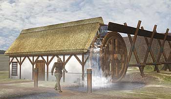
The dam would have served two purposes, it held back a lake that would have provided fish for the monks (essential for Fridays) and the water would have provided power for a mill on the south side of the dam. Documentary records and the archaeological evidence reveal that this was an overshot mill with water powering the mill wheel through a channel from above. It was used both as a corn mill for producing flour and as a fulling mill for preparing cloth.
The water supply to the dam and the level of the head of water in the lake behind it were carefully regulated. The brook above the dam is contained in a stone-lined channel with the main course running to the dam and an overflow system allowing water down the valley to other dams in the system.
|
|
|